Mt Bogong, Day Walk Grade 4, 13km
From October 22, 2020 8:00 am until October 22, 2020 5:00 pm
At Mountain Creek Campground
Posted by Dianne Ross
dianneross007@gmail.com
0412 899697
Categories: DayWalks
Hits: 3152
- Length: 13km
- ·Duration: 8 hrs
- ·Grade: 4
- ·Style: Circuit
- ·Start: Mountain Creek Camping Area;
- ·End: Camp Creek Camping Area
- ·Closest Town: Tawonga
- ·Location: Alpine National Park
- ·State: VIC
Mount Bogong
Summary
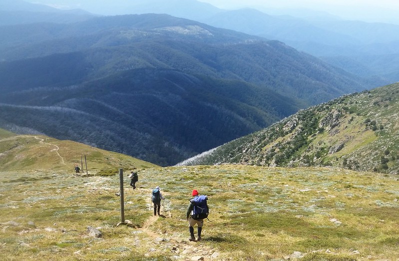
At 1986 metres high, Mt Bogong is Victoria’s tallest mountain, dwarfing all its rivals. The Mount Bogong – Staircase Spur Trail is the direct route up, beginning at the Mountain Creek Picnic Area and ending at the summit of Mt Bogong.
The track to the summit begins at the Mountain Creek Picnic Area and follows a vehicle track to the foot of the Staircase Spur, where the ascent begins through a forest of Peppermint Gums. Bivouac Hut, about halfway along the climb, offers a welcome resting place before the track passes through Snow Gums and out onto the steep rocky ridge leading to the summit plateau.
From the summit, steeply descend via Eskdale Spur, via Michelle Hut to Camp Creek.
This is a challenging WALK that should not be underestimated. During the winter months you should consider this a Grade 5 hike.
During this day trek we will pass through the following huts for breaks.
- ·Bivouac Hut. Staircase Spur, approximately 6km from the trail head and 3km from the summit. This is a small hut with pit toilet but no water tank.
- ·Michelle Hut, approximately 2km from the summit down Eskdale Spur. This is a small hut with pit toilet and water tank.
Water - tanks should not blindly rely on it having water
Walkers must be self-sufficient with food, water, first aid and camping gear,
Getting there - The hike starts and ends at Mountain Creek Camping Area. From Melbourne, drive to the small town of Tawonga (4km north of Mt Beauty). From Tawonga, Mountain Creek Roads heads east for 10.5km to the camping area. There are pleasant campsites and a pit toilet here.
Mandatory gear - for Alpine hiking – head light, Rain gear, thermal top, sun hat, beanie, gloves, map, space blanket, extra snacks, personal first aid, water purification tablets
Mobile phone reception – Reception in spots
Track Description – Steep, Rocky, Rocky steps, loose leaves/sticks, exposed on summit, not all track is sign posted. The exposed treeless plain of the summit offers little shelter in poor weather. Strong winds, fog, freezing temperatures, rain and snow are all common at this altitude. Navigation can be extremely difficult in these conditions so we will turn back at the tree line if conditions are poor or deteriorating.
Total distance: 21402 m
Max elevation: 1975 m
Min elevation: 595 m
Total climbing: 1530 m
Total descent: -1530 m
Be Prepared - This hike requires that you have a sufficient level of equipment (in good working order), fitness and self-reliance. Not recommended for beginners.
https://mvb.org.au/index.php/risk-management/event-management#WhatToBring
For information on what to bring, grading of walks please click on event management link
https://mvb.org.au/index.php/risk-management/event-management