The Big Walk Mt Buffalo - grade 3-4, 11km one way, bottom to top.

From October 25, 2024 10:00 am until October 25, 2024 4:00 pm
At Eurobin Creek Picnic Area
Posted by Iris Joss
777fdh@gmail.com
0435990770
Categories: DayWalks
Hits: 3551
Length: 11km one way (with car shuffle) from the base to the top.
Bring change for fuel cost.
-
Duration: 4-5 hrs.
-
Style: Day hike.
-
Start: Eurobin Creek Picnic Area
-
End: Mt Buffalo Chalet carpark.
-
Closest Town: Porepunkah
-
Location: Mount Buffalo National Park
-
Distance from state capital: 319km
-
State: VIC
-
Start Time: 10.00 AM
Information; The big walk is the longest walk in the Mt Buffalo NP. It begins at the bottom of the plateau at the park entrance and climbs all the way to the historic Mt Buffalo Chalet and day visitor area.
The Big Walk begins at Eurobin Creek picnic area, just inside the national park, and initially heads away from Buffalo. Across a swing bridge over pebbly Eurobin Creek, we step up into eucalypt forest.
The first 2km are the steepest but the well-formed track allows steady progress.
Criss-crossing the road and continuing uphill, those 2.9km take us through massed handsome flat pea bushes (yellow flowers and heart-shaped leaves), hickory wattles (distinctively veined leaves) and tree ferns, and they also give us through-tree views of the valley, the sometimes snow-capped Alps and a waterfall splashing down Buffalo’s granite flank.
The Big Walk heads south-east below Mackey’s Lookout and traverses a great granite slide decorated with lichen rosettes and moss. Facing the granite, we can now see the summit, suddenly within reach; backs to Buffalo we overlook the first of many views that still our feet.
A zigzag crazy-paved path that can run with water like a stream takes us onward and upward to a seasonal waterfall forming rock pools.
Above Marriott’s Lookout, from which we watch geology performing a balancing act with monumental granite wall and boulders and scarlet robins darting from tree to tree, we enter the realm of snow gums and disconcertingly beautiful skeletal mountain gums burnt in bushfires. Fording creeks and wetlands on stepping stones and boardwalks and traversing more granite, we get increasingly stunning views, with Mt Bogong, Victoria’s highest peak, showing itself on clear days.
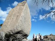
A massive boulder guards the track junction where we are turning right to follow the Gorge Heritage Walk.
Tips
Hikers should be reasonably fit and have strong footwear as The Big Walk ascends over 1000 metres in only 9 kilometres! Water and snacks should be carried along with a jacket as it is often cooler at the top.
Total distance: 10473 m
Max elevation: 1367 m
Min elevation: 320 m
Total climbing: 1340 m
Total descent: -315 m
Mobile Phone Coverage: Yes, but patchy and coverage varies by provider
GRADE 3
Suitable for most ages and fitness levels. Some bushwalking experience recommended. Track may have short steep hill sections, a rough surface and many steps.
GRADE 4
Bushwalking experience recommended. Tracks may be long, rough and very steep. Directional signage may be limited.
Mandatory Gear: Conditions in Alpine Country can change quickly. The weather at the bottom of the mountain may be very different than those at the top. In light of this – the following gear MUST be carried. Jacket – it must be waterproof! Beanie or Buff, Gloves, Space Blanket, water purfication tablets, Whistle and 2L of fluid and a snack or energy food and personal first aid kit.
Packing list for Alpine Day Hikes
Current Medical Information Form LOGIN FIRST and then it can be FOUND ON THE WEBSITE HERE
- Rain jacket
- Warm jacket
- Warm Gloves and Water Proof Over Glove
- Beanie or buff
- Suitable walk hat
- Boots in good condition
- Any medication (please inform leader if necessary Allergies etc)
- Personal first aid
- Snake bandage
- Sunscreen
- Insect repellant
- Whistle
- Space blanket
- Head torch and batteries/charger
- 2L Water to drink (some locations and walks have water on site or en route)
- Tablets or filter for water treatment (be safe rather than get a bug) (water purification tablets)
- Toilet paper and trowl to dig appropiate hole.
- For females a pstyle and or bushcloth is highly recommended, otherwise please carry used wet toilet paper in a ziplock bag to dispose of in the public toilets.
- Hand sanitiser
- Lunch and snacks.
- Hiking poles - highly recommended
- EXTRA ITEMS
Fully charged and credit loaded up phone
Camera